Applied Coastal
  • Home
  • Our Company Who We Are Join Our Team Contact
  • Shoreline and Wetland Change Assessment Coastal/Nearshore Sediment Budget Analyses Coastal & Deltaic Geology Evaluations Flood Risk and Subsidence Assessment Coastal Structure Impact & Environmental Response
Applied Coastal
  • Home/
  • About/
    • Our Company
    • Who We Are
    • Join Our Team
    • Contact
  • Services and Projects/
    • Shoreline and Wetland Change Assessment
    • Coastal/Nearshore Sediment Budget Analyses
    • Coastal & Deltaic Geology Evaluations
    • Flood Risk and Subsidence Assessment
    • Coastal Structure Impact & Environmental Response

Shoreline and Wetland Change Assessment

Shoreline changes document subaerial dynamics of the land-water boundary in response to various coastal processes, particularly those associated with storm events. Applied Coastal personnel specialize in quantification and interpretation of historical trends in shoreline position, bathymetry, and wetland area relative to dominant coastal processes. Innovative strategies have been developed to take advantage of state-of-technology advances in surveying, image analysis and interpretation, and geographic information systems (GIS), combined with a comprehensive and detailed understanding of the processes impacting coastal geomorphic change. Topographic and hydrographic surveys of coastal and nearshore environments provide a direct source of data for quantifying system response. Applied Coastal personnel analyze these data to evaluate coastal change trends at various locations along the U.S. coast in relation to normal incident coastal processes, storm impacts, relative sea-level change, and human modifications of the coast.


Capabilities

  • Drone imagery collection

  • GPS survey data collection

  • Shoreline interpretation and mapping

  • Wetland mapping

  • Land change quantification

  • Shoreline change assessment

Long Island Structure Impacts Guest User
  Long Island Structure Impacts/

The north-facing beaches and inlets of Long Island have been managed for coastal erosion and navigation for centuries.  As such, shore protection (e.g., bulkheads, revetments, groins) and navigation structures (jetties) have been constructed to stabilize portions of the coast where storm damages and channel shoaling have been persistent.  Unintended consequences of coastal structure placement often result in accelerated erosion downdrift of structures prompted by alterations to the natural sediment budget.  Applied Coastal personnel evaluated the impact of coastal structure placement at three locations along the Sound shoreline of Long Island to document their impact on erosion and storm damage reduction.

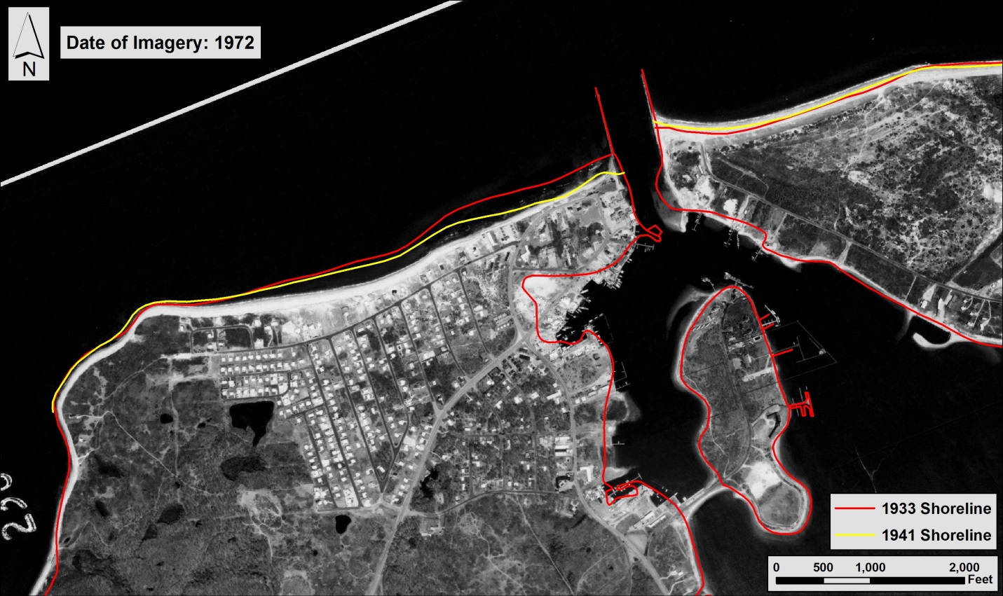
Lake Montauk:  Long-term sediment transport dynamics were evaluated for the Lake Montauk Harbor area for the periods 1892 to 1933, 1933 to 1965, and 1965 to 2004 to document natural versus engineered changes to beach erosion and coastal flood damage.  Historical shoreline positions were established with U.S. Coast and Geodetic Survey (USC&GS) topographic maps (1838, 1892, 1933, and 1965), rectified aerial photography (1980 and 1992), and a 2004 differential GPS high-water shoreline survey.  Bathymetry data (1933/34, 1943, and 1999) were used to quantify sand volume changes from the high-water line offshore to the 20-ft (NGVD) depth contour.  Sediment budget analyses indicate that restoration of historical shoreline change and sand transport rates would require the addition of about 480,000 cy of sand along beaches west of the entrance jetties.  To maintain historical trends, approximately 6,700 cy of sand should be added to the beach west of the west jetty on an annual basis, in addition to maintenance dredging.

Asharoken: A sediment budget was developed for the Asharoken coast between Crab Meadow (east) and Eatons Neck (west) for the periods 1962 to 2001 and 1976 to 2001.  Historical shoreline positions were established with U.S. Coast and Geodetic Survey topographic maps (1885/86, 1917, 1931) and rectified aerial photography (1961, 1962, 1972, 1976, 1983, 1988, 1994, 2001).  Bathymetry data for the periods 1967 (National Ocean Service) and 2001 (Gahagan and Bryant) were used to quantify sand volume changes from the high-water line offshore to the 20-ft (NGVD) depth contour.  Transport rates for both time periods are in general agreement with each other, with magnitudes increasing for the recent interval.  Net transport to the west is about 16,000 cu yd/year, the sand volume required to form Eatons Neck Spit between 1931 and 1990. 

Goldsmith Inlet:  Historical shoreline and bathymetric survey data were used to evaluate changes in sediment transport dynamics prior to and after placement of the jetty at Goldsmith Inlet.  Data indicate that the updrift side of the jetty began to fill immediately after construction (1964) and approached capacity in 1976.  Since then, the size of the fillet has remained relatively stable as a function of incident wave conditions.  Shoreline response downdrift of the jetty suggests that sediment bypassing was restored by 1980.  Based on deposition rates at the fillet prior to 1976, longshore transport was estimated at 8,000 to 10,000 cy/year.

Long Island, New York, Shoreline Change, Bathymetric Change, Sediment transport
  • Louisiana System-Wide Assessment ...
  • Cameron County Erosion Response Plan
  • Home/
  • About/
    • Our Company
    • Who We Are
    • Join Our Team
    • Contact
  • Services and Projects/
    • Shoreline and Wetland Change Assessment
    • Coastal/Nearshore Sediment Budget Analyses
    • Coastal & Deltaic Geology Evaluations
    • Flood Risk and Subsidence Assessment
    • Coastal Structure Impact & Environmental Response

Applied Coastal

Applied Coastal Research Associates, Inc.

Home / Our Company / Who We Are / Join Our Team / Contact
Coastal Change Assessment / Coastal Engineering Design / Environmental Impact Assessment & Permitting
Wave & Sediment Transport Modeling / Estuarine Hydrodynamic & Water Quality Assessment / Wetland Impacts & Marsh Restoration Design
ac-gray2.png

Corporate Headquarters: 766 Falmouth Road, Suite A-1, Mashpee, MA 02649
Nashville Office: 7003 Chadwick Drive, Suite 354, Brentwood, TN 37027