Applied Coastal
  • Home
  • Our Company Who We Are Join Our Team Contact
  • Shoreline and Wetland Change Assessment Coastal/Nearshore Sediment Budget Analyses Coastal & Deltaic Geology Evaluations Flood Risk and Subsidence Assessment Coastal Structure Impact & Environmental Response
Applied Coastal
  • Home/
  • About/
    • Our Company
    • Who We Are
    • Join Our Team
    • Contact
  • Services and Projects/
    • Shoreline and Wetland Change Assessment
    • Coastal/Nearshore Sediment Budget Analyses
    • Coastal & Deltaic Geology Evaluations
    • Flood Risk and Subsidence Assessment
    • Coastal Structure Impact & Environmental Response

Shoreline and Wetland Change Assessment

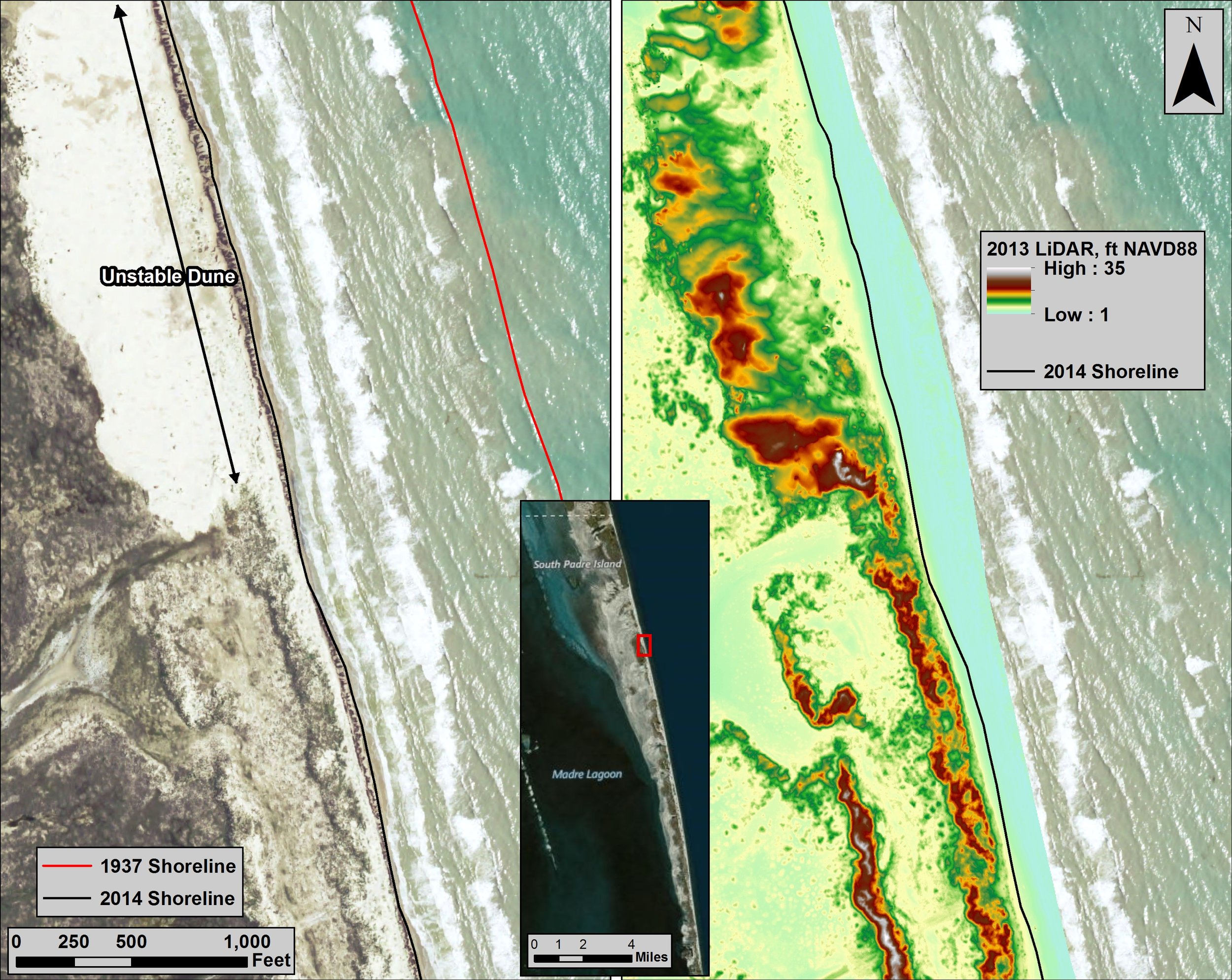
Shoreline changes document subaerial dynamics of the land-water boundary in response to various coastal processes, particularly those associated with storm events. Applied Coastal personnel specialize in quantification and interpretation of historical trends in shoreline position, bathymetry, and wetland area relative to dominant coastal processes. Innovative strategies have been developed to take advantage of state-of-technology advances in surveying, image analysis and interpretation, and geographic information systems (GIS), combined with a comprehensive and detailed understanding of the processes impacting coastal geomorphic change. Topographic and hydrographic surveys of coastal and nearshore environments provide a direct source of data for quantifying system response. Applied Coastal personnel analyze these data to evaluate coastal change trends at various locations along the U.S. coast in relation to normal incident coastal processes, storm impacts, relative sea-level change, and human modifications of the coast.


Capabilities

  • Drone imagery collection

  • GPS survey data collection

  • Shoreline interpretation and mapping

  • Wetland mapping

  • Land change quantification

  • Shoreline change assessment

Cameron County, Texas Guest User
  Cameron County, Texas/

Primary goals for the Cameron County Erosional Response Plan (ERP) are to identify beach erosion hazards, assess ways to mitigate identified hazards, and evaluate potential expenditures that may be associated with beach erosion and flood damage reduction. Long-term erosion damages must be properly evaluated relative to net cost/benefit evaluations, but storm impacts often are the primary catalyst for increased attention on the need for a long-term comprehensive management/restoration strategy. Development and implementation of a long-term Erosional Response Plan for Cameron County requires an understanding of regional sediment transport processes, coupled with a long-term operational strategy to evaluate the best means for allocating available sand resources to existing and future projects.

Applied Coastal personnel evaluated the impact of island movement and degradation on potential development along 16-miles of Gulf shoreline in the unincorporated limits north of the city of South Padre Island, and along the Boca Chica coast. The project focused on evaluating shoreline position changes and surface elevation characteristics for the outer coast shoreline of Cameron County. Transport rate estimates and surface elevation changes were derived from existing existing literature and map and photographic data sources to provide reliable measurements for restoration cost estimates, setback guidelines, and potential upland development. Coastal management actions were recommended as a guide to plan, design, evaluate, and maintain future shoreline positions.

Cameron County, Texas, Shoreline Change, Lidar
  • Impact of Navigation and Shore ...
  • Evaluation of Channel Dredging on ...
  • Home/
  • About/
    • Our Company
    • Who We Are
    • Join Our Team
    • Contact
  • Services and Projects/
    • Shoreline and Wetland Change Assessment
    • Coastal/Nearshore Sediment Budget Analyses
    • Coastal & Deltaic Geology Evaluations
    • Flood Risk and Subsidence Assessment
    • Coastal Structure Impact & Environmental Response

Applied Coastal

Applied Coastal Research Associates, Inc.

Home / Our Company / Who We Are / Join Our Team / Contact
Coastal Change Assessment / Coastal Engineering Design / Environmental Impact Assessment & Permitting
Wave & Sediment Transport Modeling / Estuarine Hydrodynamic & Water Quality Assessment / Wetland Impacts & Marsh Restoration Design
ac-gray2.png

Corporate Headquarters: 766 Falmouth Road, Suite A-1, Mashpee, MA 02649
Nashville Office: 7003 Chadwick Drive, Suite 354, Brentwood, TN 37027